
Two communities in northwestern Ontario are being evacuated because of the threat of forest fires, while another is being placed on alert.
Provincial Police states that mandatory evacuation orders have been issued for residents of Armstrong and nearby Whitesand First Nation.
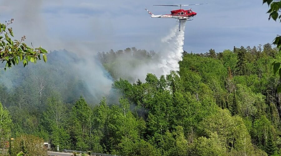
Several fires are burning nearby, bringing smoke into the two communities.
The largest of the blazes has been burning near Collins since the end of May and has blackened more than 14,000 hectares.
Emergency crews are in communities to assist with the evacuations.
In the meantime, Ignace is being monitored for what the OPP call an evolving situation.
No other details were provided.
The Ministry of Natural Resources says 31 new wildland fires were reported on Monday.
They include
- Fort Frances 38 (FOR038) is located north of Hwy. 11 near Duck Lake, approximately 26 kilometres east of Atikokan. The 5.0-hectare fire received air attack on July 13 and is not under control.
- Fort Frances 37 (FOR037) is located north of Crooked Lake in Quetico Provincial Park, approximately 61 kilometres south of Atikokan. The 5-hectare fire is being observed.
- Fort Frances 36 (FOR036) is located near French Lake, approximately 36 kilometres east of Atikokan. The 0.2-hectare fire is being held.
- Sioux Lookout 89 (SLK089) is located near Hill Lake, approximately 19 kilometres north of the Ojibway Nation of Saugeen. The fire is not under control at 55 hectares.
- Sioux Lookout 88 (SLK088) is located near Doghole Lake, approximately 8 kilometres southwest of Mishkeegogamang First Nation. The fire is not under control at 0.2 hectares.
- Sioux Lookout 87 (SLK 087) is located on an island on Lake of Bays, approximately 40 kilometres southeast of Sioux Lookout. The fire is not under control at 0.2 hectares.
- Sioux Lookout 86 (300 hectares) and Sioux Lookout 85 (0.3 hectares) are located near Pashkokogan Lake, approximately 18 and 22 kilometres south of Mishkeegogamang First Nation, respectively.
- Sioux Lookout 84 (SLK084) is located near DeLesseps Lake, approximately 71 kilometres south of Mishkeegogamang First Nation. The 143-hectare fire is not under control.
- Dryden 36 (DRY036) is located near Lower Moosehide Lake, approximately 21 kilometres southwest of Ignace. The fire is not under control at 60 hectares.
- Dryden 35 (DRY035) is located near Weaver Lake, approximately 72 kilometres north of Upsala. The fire is not under control at 500 hectares.
- Dryden 34 (DRY034) is located near Harmon Lake, approximately 28 kilometres south of the Allanwater Bridge. The fire is not under control at 400 hectares.
- Dryden 33 (DRY033) is located on a southern peninsula of Eagle Lake, approximately 11 kilometres southwest of Migisi Sahgaigan First Nation. The fire is not under control at 3 hectares.
- Dryden 32 (DRY032) was located adjacent to Hwy. 647 near Blue Lake Provincial Park. The fire was called out at 0.1 hectares.
- Thunder Bay 59 (THU059) is located near the northern shore of Lake Nipigon, approximately 35 kilometres east of Armstrong. The fire is not under control at 0.2 hectares.
- Thunder Bay 58 (THU058) is located approximately 2 kilometres south of Pallisades Rd. near the junction of Moore Rd. The 1.0 hectare fire received air attack from waterbombers this afternoon. The fire is not under control.
- Thunder Bay 57 (THU 057) is located approximately 5.5 kilometres north of Whitefish Lake. The fire is not under control at 0.5 hectares.
- Thunder Bay 56 (THU056) is located near Wawang Lake, approximately 41 kilometres north of Upsala. The 400-hectare fire is not under control.
- Thunder Bay 55 (THU055) is located near Smoothrock Lake in Wabakimi Provincial Park, approximately 37 kilometres northwest of Armstrong. The fire is not under control at 5 hectares.
- Thunder Bay 54 (THU 054) is located near Brett Lake, approximately 59 kilometres west of Gull River First Nation. The 400-hectare fire is not under control.
- Thunder Bay 53 (1.0 hectare), Thunder Bay 50 (25 hectares) and Thunder Bay 49 (0.1 hectare) are located west of Caribou Lake in Wabakimi Provincial Park, approximately 21 kilometres north of Armstrong.
- Thunder Bay 52 (THU052) is located east of Wabakimi Provincial Park, approximately 37 kilometres north of Armstrong. The fire is not under control at 0.1 hectares.
- Thunder Bay 51 (THU 051) is located approximately 6.3 kilometres northwest of Whitefish Lake. The 9.0-hectare fire received air attack from waterbombers on July 13. The fire remains not under control.
- Nipigon 40 (NIP040) is located near Opichaun Lake, approximately 42 kilometres south of Fort Hope First Nation. The 1.0-hectare fire is not under control.
- Nipigon 39 (0.5 hectares) and Nipigon 38 (1.5 hectares) are located near Sollas Lake, approximately 38 kilometres northwest of Aroland. Both fires are not under control.
- Nipigon 37 (NIP037) is located south of Toronto Lake, approximately 61 kilometres west of Aroland. The 35-hectare fire is not under control.
- Nipigon 36 (NIP036) is located near the north shore of Miminiska Lake, approximately 56 kilometres west of Fort Hope First Nation.
- Nipigon 35 (NIP035) is located south of Luella Lake, approximately 72 kilometres southwest of Fort Hope First Nation. The 150-hectare fire is being observed.
As of Tuesday morning, 128 fires were active across northwestern Ontario.
Fifty-three are considered not under control, with the MNR watching closely 63 fires, but taking no immediate action to put them out as they are posing no threat to the public or property.